Paleozoic Sites, cont'd
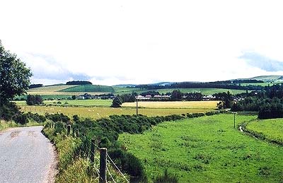
 3) Much Wenlock: The Silurian Much Wenlock exposures are located near the town of the same name in Shropshire, England, on the Welsh Borderlands. This was the edge of a vast Middle Silurian reef, now exposed as a limestone ridge, the Wenlock Edge -- just one more set of wooded Shropshire hills in a now absurdly civilized setting.
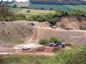
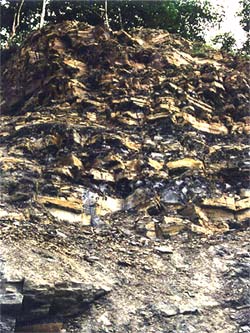
The Ordovician and Silurian have left us few famous sites. We chose the Much Wenlock site because it is one of the best of a bad lot. At that, it's not really so bad. Well over 600 species of invertebrates have been found there. These include crinoids, corals, brachiopods, trilobites, algae and bryozoans. Much Wenlock may be less famous than the two Cambrian sites because there are few vertebrates. No one expects vertebrates in the Cambrian, but the early Silurian is part of the dark age of hidden vertebrate diversity, and its rather frustrating that so few are to be found at Much Wenlock. A more serious problem with the Much Wenlock exposures is that many are in limestone quarries (such as the Farley Quarry in the image) which are long abandoned and now filled with water.
As a paleontological site, Much Wenlock is about as old as geology itself. It is part of the region from which the Silurian System was first described by Murchison in the late 1830's. The astute reader may already have deduced as much from the fact that the "Middle Silurian" is officially named the Wenlock. From northwest to southeast, virtually the entire Silurian system is laid out in a series of gently sloping ridges. The impact of Much Wenlock on paleontology lies partly in that early discovery and partly in the early opportunity it gave geologists to put together a the components of a fairly complete Paleozoic ecosystem.
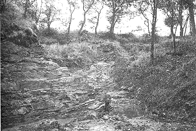
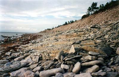 4) Saaremaa Island: If its Silurian vertebrates you're after, this is the better choice. Saaremaa Island is located just off the coast of Estonia, in the Baltic Sea. The entire island rests on Wenlock to Ludlow reef limestones which were buried under Baltic marine sediments until early Holocene times. The topography is quite low, so exposures are relatively rare except on a few bluffs referred to locally (and rather optimistically) as "cliffs." During most of the last century, it was the private preserve of a few scientists from Moscow, Talinn, and occasionally Stockholm.
Saaremaa is not particularly well known, although it has yeilded any number of often beautifully preserved jawless fishes, in addition to eurypterids and other shelled invertebrates. Perhaps we over-rate its importance; but perhaps not. Our belief is that more systematic exploration of Saaremaa and some even more obscure sites in Poland, has the potential to transform our understanding of vertebrate evolution.
 5) Spitsbergen: This location is sometimes spoken of in the same breath as Saaremaa. Spitsbergen is actually a bit large to be referred to as a "site." It is the largest member of the Svalbard, a large arctic archipelago located well north of Norway. It is unreasonably cold and beautiful and is inhabited entirely by scientists and polar bears. At least that is the impression one gets. Undoubtedly this is an exaggeration, and many of the polar bears will turn out to be Norwegian scientists -- or vice versa. The base of the sedimentary sequence at Spitsbergen is the Red Bay Formation, largely of Ludlow and Pridoli age. The exposures continue right into the Cenozoic in various localities. For paleontologists, however, most of the interest is in the Red Bay and Early Devonian Wood Bay groups, both exposed in the relatively glacier-free center of the island.
These are immense exposures. Collection collections are difficult, and vertebrate fossils are seldom common in any Paleozoic site. However, with whole mountains of Ludlow and Early Devonian sediments available, remarkable finds have been made. Fossil prospecting has been going on here since approximately the 1880's. Some well-known results of that work are the three-dimensional fossils of Osteostracan headshields -- with the internal cartilage so perfectly preserved that Janvier, Wängsjö, and others have been able to trace, in detail, the branching paths of the cranial nerves in fishes dead for 400 My.
 6) The Rhynie Chert: this is one of the earliest more-or-less terrestrial sites known. Rhynie is located in Aberdeenshire, Scotland, about 50 km west of Aberdeen. It was first found and its plant fossils studied by Robert Kidston and William Lang in 1917. The Rhynie Chert represents a swampy peat bog from the Early Devonian with the peculiar addition of mineral springs. The plant tissues were preserved by silicate diagenesis, in which the plant tissues were replaced by silicates from the springs almost immediately after burial. The preservation is practically miracuous in some cases, extending almost to subcellular organelles. In addition to plants, there are Fungi and numerous arthropods, mostly crustaceans and spiders, with a few early insects.
The Rhynie Chert has allowed us to study early terrestrial plants in considerable detail. However, more than this, it shows how the entire community was structured. The community in question was, no doubt, aberrant for that time or any other. Nevertheless, we see every component from predatory spiders down to fungal saprophytes. No other site from a comparable time period gives us such a detailed look at an entire terrestrial community.
 7) Escuminac or Miguasha: The Canadian towns of Miguasha and Escuminac [3]are located on the Gaspé Penninsula, on the Quebec side of the rather optimistically named Baie-des-Chaleurs, across from the north coast of New Brunswick. This exceedingly famous site is referred to by both names because the best exposure of the Escuminac Formation is at Escuminac Cliff which, naturally enough, is located in Miguasha. This exposure is of Frasnian Late Devonian) age. It was first discovered in 1842 by Dr. Abraham Gesner (the man who invented kerosene). It was then forgotten until rediscovered in 1879 by Robert W. Ells of the Canadian Geological Survey. Miguasha represents a near-shore environment, parts of which are choked with ferns and terrestrial plants. The best fossils are found in calcareous nodules which probably allowed very fine and undistorted replacement of bone by carbonates.
It is now a UNESCO World Heritage site, so designated because "[t]he area is of paramount importance in having the greatest number and best preserved fossil specimens found anywhere in the world of the lobe-finned fishes that gave rise to the first four-legged, air-breathing terrestrial vertebrates -- the tetrapodes [sic]." Close enough, we suppose, for government work.
In some ways, Miguasha is a monument to one man, Erik Jarvik. Over the course of about 50 years, Jarvik published a series of papers on painstakingly prepared specimens of Eusthenopteron, "Le Prince de Miguasha." These were ground down, in tiny increments, with each new surface studied in minute detail, until the entire three-dimensional structure of the fish's cranial and axial skeleton was understood. This work was complemented by two massive papers in 1970 by Mahala Andrews and T. Stanley Westoll, who said what there was to say about the appendicular skeleton. Andrews & Westoll (1970), (1970a). At the time, and perhaps until just the last few years, this was the most complete reconstruction of a paleozoic vertebrate ever completed.
It is impossible to overstate the importance of this kind of detailed restoration. In the Late Nineteenth Century, Huxley was instrumental in changing paleontology from a branch of geology which happened to study once-living rocks, to an evolution-centered science. Huxley had lots of help, but he set the standard. In the same way, Jarvik's work on Eusthenopteron helped set the standard which is now allowing paleontology to move from the evolution of structure to the evolution of function. This requires knowing, not just where the bones are and what general shape they had, but exactly how they articulated, where and how large the attached muscle masses were, and how the moving parts were ennervated to form a living, moving organism.
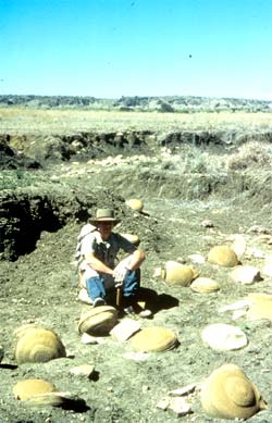 8) Gogo Reef: The Gogo reef looks, from the air, like a reef that someone left out in the Australian desert. Since Australians tend to be a rather straightforward folk, that's exactly what it is. The Gogo Reef is in the northwestern part of the State of Western Australia in what is vaguely referred to as the Kimberly District. It is conveniently located near nothing. There is no road. It is, in fact, so far from any town with a name recognizeable by non-Australians that it would be pointless to get any more specific. Even if we recognized the name, we would inevitably pronounce it wrong, and the Australians would laugh at us -- not a pretty sound. The Gogo is truly in the middle of nowhere. The image shows some typical limestone concretions from the Gogo, presided over by a typical Australian paleontologist, John Long. He's probably laughing at us anyway.
The whole business is very straightforward and Australian. During the Frasnian, the Gogo Reef was in the water, where it belonged. Things died. Being dead, they fell off the reef and ended up on anoxic bottoms. Tough luck. On the bottom, the chemistry and temperature got them very slowly covered with precipitating limestone. There's no soft tissue preservation, mind you, but no crushing, either. The fossils are completely three-dimensional and cemented into limestone nodules. The Australians pick up the nodules, tap them briskly, and -- pop! -- there's your fish, eurypterid, or whatever. They then take the thing home and reverse the natural process by very slowly dissolving the limestone with dilute acetic acid. Then they turn on the light, open a beer, and very slowly begin to describe the fish, eurypterid, or whatever. Later, sometimes decades later, they turn off the light, kick the empties out of the way, and publish -- long after the rest of us have developed ulcers and bald spots from waiting -- or have ended up on our own anoxic bottoms.
 9)
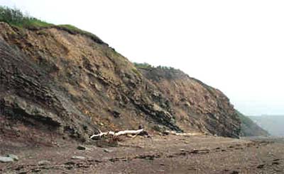
East Kirkton: East Kirkton Quarry is located in the town of Bathgate, just about dead in the middle of the legendary (for fossils) Scottish Midland Valley. According to Clack 2002), from whence our image comes, Bathgate is a suburb of Edinburgh. However, it may just as easily be called a suburb of Glasgow. Undoubtedly the Edinburgh cachet adds a few percent to sale prices in the housing development next door to the quarry. In the 1830's and 40's, when the quarry was active, it yeilded some interesting Carboniferous plants and eurypterids, but nothing startling. When the quarry closed, the place was forgotten until (as Clack relates) Stan Wood found tetrapods there in 1984. The quarry was then re-opened and literally dozens of tetrapods came rolling out: Balanerpeton(a temnospondyl), Sivanerpeton and Eldeceeon (basal anthracosaurs), all in multiple copies, and one spectacular proto-amniote, Westlothiana.
9)
East Kirkton: East Kirkton Quarry is located in the town of Bathgate, just about dead in the middle of the legendary (for fossils) Scottish Midland Valley. According to Clack 2002), from whence our image comes, Bathgate is a suburb of Edinburgh. However, it may just as easily be called a suburb of Glasgow. Undoubtedly the Edinburgh cachet adds a few percent to sale prices in the housing development next door to the quarry. In the 1830's and 40's, when the quarry was active, it yeilded some interesting Carboniferous plants and eurypterids, but nothing startling. When the quarry closed, the place was forgotten until (as Clack relates) Stan Wood found tetrapods there in 1984. The quarry was then re-opened and literally dozens of tetrapods came rolling out: Balanerpeton(a temnospondyl), Sivanerpeton and Eldeceeon (basal anthracosaurs), all in multiple copies, and one spectacular proto-amniote, Westlothiana.
Not only were these finds interesting in their own right, but they helped to fill in "Romer's Gap," the temporal and phylogenetic gap between rather fishy Late Devonian forms and the amniotes of the Pennsylvanian. East Kirkton is Late Viséan age, so its in the right time frame. Its a big Gap, and we've a very long way to go, but East Kirkton a good start. Incidently, The small figure in the pit is Dr. Clack herself, who is here caught in flagrantes relictos loosely, "among a bunch of amazing fossils").
 10) Joggins: The seaside cliffs of Joggins, Nova Scotia are another Canadian UNESCO World Heritage site. This is the famous place where Dendrerpeton was stumped in the Pennsylvanian. The Joggins fossils are probably of Bashkirian Age. Their exact placement in time is still somewhat controversial. The site probably represents a coastal swamp thickly covered with large, tree-sized lycopsids. These large lycopsids were not as structurally sound as today's angiosperms. Their trunks seem to have broken frequently. The central column of lycopsids is soft and rots out much faster than the outer trunk. Normal decay thus left hollow stumps, which became either homes or traps for small animals living in the swamp. Their remains can be found in fossilized stumps, frequently in an excellent state of preservation. The basal temnospondyl, Dendrerpeton and several other small vertebrates are among those which have been recovered because of this unique mode of preservation.
One of the reasons that Joggins is so significant is that it has preserved what are normally the rarest fossils -- the small vertebrates; and it has preserved them often in fully-articulated form. This is a valuable check on our ideas about the evolution of vertebrates as we approach the huge diversity of forms in the Permian and beyond.
On Beyond Joggins: some day we hope to return and fill in the Karoo locales, Isheevo, Ocher, and other Permian sites. However, Permian tetrapod sites are really the products of a whole different taphonomic style. For the moment, this will have to do.
ATW041123. Text public domain. No rights reserved.
page uploaded on Kheper Site on 28 May 1998, page uploaded on Palaeos Site 9 April 2002,
checked ATW050504, last modified ATW041118
except where otherwise attributed, content ©
M. Alan Kazlev 1998-2002
bars and buttons from
Jelane's families of graphics