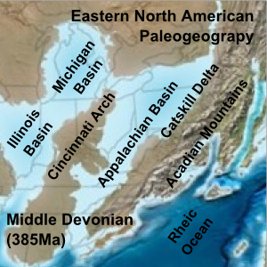
Paleogeographic reconstruction showing the Appalachian Basin area during the Middle Devonian period. Modified from original map by Ron Blakey, "Paleogeography and Geologic Evolution of North America" Wikipedia
| Paleogeography | ||
| PALEOGEOGRAPHY | Paleogeography |
| Africa (alphabetical listing of continents) |
Earth |
Earth |
Alphabetical list includes |
|
Paleogeographic reconstruction showing the Appalachian Basin area during the Middle Devonian period. Modified from original map by Ron Blakey, "Paleogeography and Geologic Evolution of North America" Wikipedia |
As the content previously on this page has been relocated to the new index page (as part of the renovations of updating the Palaeos site), some material was needed for the present page. The following therefore is adapted from Wikipedia, but also modified, making it a fork
Palaeogeography, or paleogeography is the study of the geography of the Earth in past ages, especially deep time and the geological past. If the topic is landforms it could also be called paleogeomorphology.
Paleogeographic analysis is used in petroleum geology for the detailed study of sedimentary basins. Paleogeographers also study the sedimentary environment associated with fossils to aid in the understanding of evolutionary development of extinct species. Paleogeography also provides critical evidence for the development of continental drift and current plate tectonic theories. Knowledge of the shape and latitudinal location of supercontinents such as Pangaea and ancient oceans such as Panthalassa result from paleogeographic studies.
Not to be confused with palaeography (the study of ancient handwriting).
Also from Wikipedia, in this case taken verbatim:
Paleomaps are maps of continents and mountain ranges in the distant past or future. Until the 1960s, paleomaps were not very satisfactory as it was difficult to understand many quite distinctive features. For example huge river deltas seemed to be associated with what must have been quite small drainage basins. With the discovery of plate tectonics, it became apparent that land masses move relative to one another over time. Ancient geologic features started to make far more sense. It is now possible to construct maps that are probably fairly accurate for continental positions over several hundred million years. Before the Cambrian period, it becomes much more difficult since there are fewer rock exposures preserved. The state of large regions of the Earth becomes unknowable in the distant past. Where rocks are exposed, latitudes can often be determined from the orientation of preserved magnetic fields (see paleomagnetism) but longitudes are based on projections that are increasingly uncertain as one gets further from the present.
page by MAK110919, edited RFVS111106