| Palaeos: | Paleogeography | |
| PALEOGEOGRAPHY | Rodinia |
| Page Back | Unit Up | Unit Home | Page Next | Palaeogeography | Plate Tectonics |
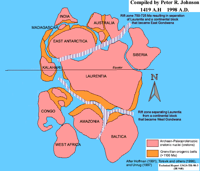 It is very unlikely that Rodinia was the first supercontinent. However, it was certainly the
first global supercontinent -- incorporating essentially all of the Earth's
continents -- about which we have solid information. Rodinia formed
perhaps as early as 1200 Mya. Most of its mass was probably located in the
low latitudes of the Northern Hemisphere. However, the actual
arrangement of cratons is still being debated. Laurentia (North America)
seems to have been the hub of Rodinia. At the time, Laurentia was rotated
about 90° clockwise with respect to its present orientation, so that Greenland
was on the East side. Baltica (northern and eastern Europe) and Siberia
lay off to the southeast. Africa and South America had not yet formed, but
various bits and pieces were spread out in a long arc on the west side.
Australia and India were probably to the north or northwest. The position
of other cratons is even less well known.
It is very unlikely that Rodinia was the first supercontinent. However, it was certainly the
first global supercontinent -- incorporating essentially all of the Earth's
continents -- about which we have solid information. Rodinia formed
perhaps as early as 1200 Mya. Most of its mass was probably located in the
low latitudes of the Northern Hemisphere. However, the actual
arrangement of cratons is still being debated. Laurentia (North America)
seems to have been the hub of Rodinia. At the time, Laurentia was rotated
about 90° clockwise with respect to its present orientation, so that Greenland
was on the East side. Baltica (northern and eastern Europe) and Siberia
lay off to the southeast. Africa and South America had not yet formed, but
various bits and pieces were spread out in a long arc on the west side.
Australia and India were probably to the north or northwest. The position
of other cratons is even less well known.
Rodinia was ripped apart during the Early Neoproterozoic (Tonian) by the Grenville Orogeny, which left enormous amounts of volcanic rock on many of today's continents. Rodinia was surrounded by a single ocean, called the Iapetus Ocean or Sea. Towards the end of the Proterozoic, this supercontinent fragmented, giving rise to the late Ediacaran continents of Pannotia, Siberia, and North China. From Pannotia in turn came the diverse continents of Laurentia, Gondwana, and Baltica.
| Links |
![]() Rodinia:
map from the Paleo-Map Project
Rodinia:
map from the Paleo-Map Project
![]() History
of Global Plate Motions: more maps
History
of Global Plate Motions: more maps